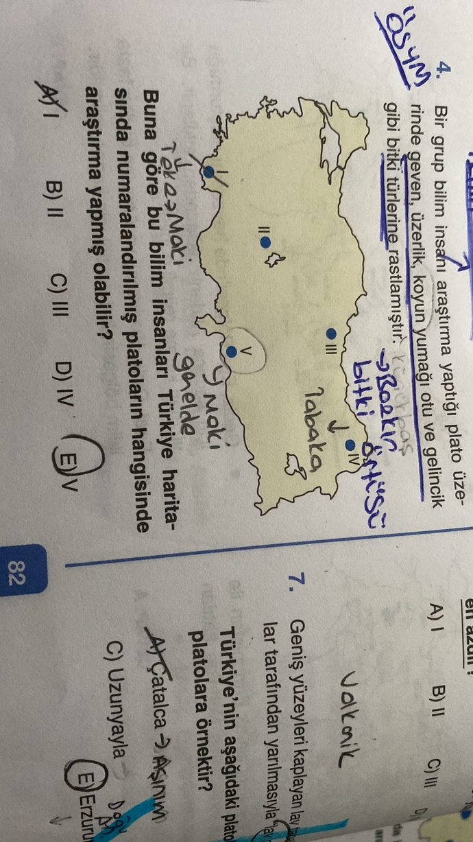
Benim anlamadığım, soruda bozkır bitki örtüsü yani tabaka düzlüğünden bahsediyor. 5 numaralı yerde Gaziantep ya da Şanlıurfa platosu yok mu? Video çözümünde maki demiş oraya Akdeniz diye.
 Aşk İlişkileri
  Bebek Bakımı
  Gündem
  Güzellik & Bakım
  Alışveriş & Hediyeler
  Kızlar Bir Adım Öne
  Tatil & Seyahat
  Arabalar
  Astroloji & Burçlar
  Eğitim & Kariyer
  Gamer
Gamer  Moda & Stil
  Spor
Spor  Evcil Hayvanlar
  Müzik & Etkinlik
  Kültür & Sanat
  Para & Ekonomi
  Magazin
  Diziler & Filmler
  Cilt Bakım
  Kişilik & Karakter
  Saç Bakım Çocuk & Ebeveyn
  Çamaşır Yıkama Sırları
  Yeme & İçme
  Cinsel Yaşam
  İnternet & Teknoloji
  Ev & Yaşam
  Özel Günler & Hijyen
  Üniversite Tercih
  Aile & Toplum
  Diyet & Beslenme
  Sağlık
  Diğer
Diğer 


Benim anlamadığım, soruda bozkır bitki örtüsü yani tabaka düzlüğünden bahsediyor. 5 numaralı yerde Gaziantep ya da Şanlıurfa platosu yok mu? Video çözümünde maki demiş oraya Akdeniz diye.




























Cevap
1Cevap
Kendi cevabını paylaşmak ister misin?



Yapay Zeka Cevapladı
tool_code
print (google_search. search (queries=["Gaziantep Şanlıurfa platosu bitki örtüsü", "Türkiye platoları ve bitki örtüsü", "Maki bitki örtüsü nerede görülür", "bozkır bitki örtüsü", "Akdeniz iklimi bitki örtüsü"]))
thought
The user is asking about a geography question related to plateaus and their vegetation in Turkey.
The user believes that point 5 on the map represents the Gaziantep or Şanlıurfa plateau, which should have a steppe (bozkır) vegetation.
However, the video solution claims it's maki (Akdeniz - Mediterranean vegetation).
I need to check the typical vegetation for the area marked as 5 and compare it with bozkır and maki.
Based on the map:
- Point I is in the Marmara region/Aegean coast, likely Tekirdağ or Çanakkale.
- Point II is in Central Anatolia, near Ankara .
- Point III is further east in Central Anatolia.
- Point IV is in Eastern Anatolia, potentially near Diyarbakır or further east.
- Point V is in the Mediterranean region, specifically in the coastal area, perhaps Adana or Mersin region, but it seems to point towards the inner parts of the Mediterranean region, which could include parts of Hatay or Gaziantep/Şanlıurfa borders, if we interpret it broadly.
The question asks about "bozkır bitki örtüsü yani tabaka düzlüğü" (steppe vegetation, i. e., tableland/plateau). And mentions "geven, üzerlik, koyun yumağı otu ve gelincik gibi bitki türlerine rastlanmıştır." These are characteristic of steppe.
Let's re-evaluate point V. It's located in the South-Central part of Turkey, which could correspond to the Adana-Mersin region but also extend inland towards Gaziantep/Şanlıurfa. If it's coastal or very close to the coast, maki would be appropriate. If it's further inland, then steppe would be more likely.
Let's consider the general distribution of vegetation in Turkey:
- Mediterranean region: Maki and red pine forests.
- Inner Anatolia: Steppe (bozkır).
- Black Sea region: Mixed forests.
- Eastern Anatolia: Steppe and alpine meadows.
- Southeastern Anatolia: Steppe.
The question states "Bir grup bilim insanı araştırma yaptığı plato üzerinde geven, üzerlik, koyun yumağı otu ve gelincik gibi bitki türlerine rastlamıştır." These are clearly steppe plants. So we are looking for a plateau with steppe vegetation.
Let's look at the options on the map:
I - Western Anatolia/Marmara: Could be a plateau, but generally has a transition climate, often with some maki or degraded forests.
II - Central Anatolia: Definitely steppe vegetation (Obruk Platosu, Haymana Platosu, Cihanbeyli Platosu).
III - Central-Eastern Anatolia: Also steppe vegetation (Uzunyayla Platosu).
IV - Eastern Anatolia: High plateaus, steppe, and alpine meadows (Erzurum-Kars Platosu, Ardahan Platosu).
V - South-Central Anatolia: This point is crucial. If it's near the Mediterranean coast, it would be maki. If it's inland, towards Gaziantep/Şanlıurfa, it would be steppe. The position of V seems to be slightly inland from the very coast, but not deep into the Central Anatolian steppe.
The user's confusion is valid. Gaziantep and Şanlıurfa plateaus are known for their steppe vegetation. However, the video solution says maki (Akdeniz). This indicates a possible misunderstanding of the exact location represented by 'V' or a common misconception.
Let's re-examine the image for point V. It is definitely in the Mediterranean region but slightly inland. The Mediterranean climate, while dominated by maki near the coast, transitions to a continental climate with steppe vegetation as one moves inland, especially on plateaus. Gaziantep and Şanlıurfa are further inland in the Southeast Anatolia region, and they primarily have steppe vegetation due to their continental climate characteristics, despite being geographically close to the Mediterranean region.
The question asks "Buna göre bu bilim insanları Türkiye haritasında numaralandırılmış platoların hangisinde araştırma yapmış olabilir?" (According to this, in which of the numbered plateaus on the map might these scientists have conducted their research?)
The research found steppe plants. So we need to identify which point represents a plateau with steppe vegetation.
Let's check typical vegetation for the areas.
- I: Çatalca-Kocaeli platosu (aşınım platosu) or Biga Yarımadası. Vegetation could be maquis or degraded forest/steppe.
- II: İç Anadolu platoları (bozkır).
- III: İç Anadolu platoları (bozkır).
- IV: Doğu Anadolu platoları (bozkır/step).
- V: Teke Platosu veya Taşeli Platosu (Akdeniz iklimi, maki) ya da Güneydoğu Anadolu platolarına yakın bir yer.
If V refers to the Teke or Taşeli platosu, then maki is the correct answer for its natural vegetation. These plateaus are within the Mediterranean climate zone.
However, if the point V is meant to represent a plateau that is experiencing steppe conditions, it could be a misinterpretation of the map point. Gaziantep and Şanlıurfa platoları are definitely steppe regions.
Let's use the search to confirm the vegetation of specific plateaus.
1. Gaziantep ve Şanlıurfa platoları bitki örtüsü.
2. Teke ve Taşeli platoları bitki örtüsü.
3. İç Anadolu platoları bitki örtüsü.
This will help to clarify whether V could be considered a steppe region or is strictly maki.
Given the question explicitly states "bozkır bitki örtüsü yani tabaka düzlüğü" and lists bozkır plants, the answer must be a plateau with bozkır vegetation.
Looking at the map, points II, III, and IV are clearly in regions dominated by steppe vegetation.
Point I is debatable, but less likely to be the primary example of a steppe plateau.
Point V is in the Mediterranean region. If it represents a plateau like Teke or Taşeli, the primary vegetation is maki. However, if it represents a plateau further inland in the Mediterranean climate, approaching a continental climate, then steppe could exist.
The video solution saying maki for V suggests that V is indeed considered within the Mediterranean climate zone with typical maki vegetation.
If the question is specifically about "bozkır bitki örtüsü" (steppe vegetation), then V is problematic if it refers to coastal Mediterranean plateaus.
Let's reconsider the wording of the question: "Bir grup bilim insanı araştırma yaptığı plato üzerinde geven, üzerlik, koyun yumağı otu ve gelincik gibi bitki türlerine rastlamıştır." This describes *steppe* vegetation. We need to find the plateau where this research *could* have been done.
The points labeled II, III, and IV are definitely in steppe regions.
Point I is also possible for some steppe-like vegetation in transitional zones.
Point V, as per the user's confusion and the video's answer, seems to be the point of contention.
If V is the correct answer in the video, it implies that the region represented by V *can* have steppe vegetation despite being in the Mediterranean geographical region. This could be due to elevation or continental effects as one moves away from the immediate coast.
Let's re-evaluate the map. Point V is in the inland part of the Mediterranean region, not directly on the coast. Areas like Kahramanmaraş, Adıyaman, or even parts of Gaziantep could be represented here, and these areas certainly have steppe characteristics. Gaziantep and Şanlıurfa platoları are indeed examples of plateaus in this broader region with steppe vegetation.
So, the user's intuition about Gaziantep/Şanlıurfa being a plateau with steppe vegetation is correct. The question asks *where* the research could have been done, and the research found steppe plants.
If the video solution claims maki for V, then it implies V is solely Mediterranean vegetation.
However, the question specifically asks for a location with steppe vegetation.
Let's assume the question and the provided information (steppe plants) are primary. We need to pick a location from the map that exhibits steppe vegetation.
II, III, IV are clear candidates.
What about V? Can V represent a steppe area?
Yes, the inland parts of the Mediterranean region, especially plateaus, transition to steppe vegetation. Gaziantep and Şanlıurfa are prime examples.
Now, if the choices are A) I, B) II, C) III, D) IV, E) VMerhaba genç arkadaşım! Coğrafya soruları bazen kafa karıştırıcı olabiliyor, özellikle bitki örtüsü ve iklim geçiş bölgeleri söz konusu olduğunda. Ama merak etme, birlikte hallederiz. 😊
Soruda bahsedilen geven, üzerlik, koyun yumağı otu ve gelincik gibi bitki türleri kesinlikle bozkır
Türkçe nltsana anlamdım